Mt. Shasta
Campgrounds
Mt. Shasta, CA
CAMPGROUNDS

![]()
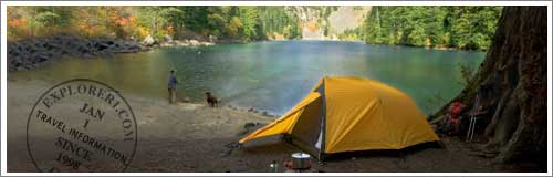
Mount Shasta Campgrounds and Camping
Mt. Shasta Area
Recreation in the Mount Shasta area centers on the two designated wilderness areas of Mount Shasta and Castle Crags. Dominating the landscape for several hundred miles in all directions, Mount Shasta looms 14,162 feet, a beautiful snow-cloaked massif, second only to Mount Rainier in height among the famous Cascade Range volcanoes. No trails lead up Mount Shasta, but trails provide access to the Wilderness and the foot of the mountain.
The Wilderness shares its southern border with Castle Crags State Park. You`ll find 27.8 miles of maintained trails starting from nine trailheads. The Pacific Crest Trail rambles for 19 miles through the area. More
Current list of Road Closures, Campground & Trail information.
Featured Advertisers


Castle Lake Campground (elevation 5280')
The area has 6 campsites and it can accommodate RVs up to 16' long. No piped water.
Gumboot Campground (elevation 6080')
The area has 4 campsites and it can accommodate RVs up to 10' long. No piped water.
McBride Springs Campground (elevation 4880')
The park has 9 campsites and it can accommodate RVs up to 10' long. Fresh water is available.
Panther Meadows Campground (elevation 7450')
The park has 10 campsites that are accessible by foot only. No RVs. No piped water.
Sims Flat Campground (elevation 1600')
The area has 20 campsites and it can accommodate RVs up to 24' long. Fresh water is available and it is wheelchair accessible.
Dispersed Camping
Areas for Dispersed Camping at Shasta Lake Area
The Castle Crags Wilderness was established in 1984 with the passage of the California Wilderness Act. This 10,500 acre addition to the National Wilderness Preservation System, along with lands within Castle Crags State Park, contains towering granite spires, steep sided canyons, and a few alpine lakes. Most of the area is covered by high brushfields and rocky outcrops with a few wet meadows in the creek headwaters. Mixed conifer forests can be found on the north, east and west facing slopes. Geology Castle Crags is actually a part of the vast Klamath Mountains Geological Province that includes much of northwestern California and Southwestern Oregon. Rocks within the province consist predominantly of volcanic and sedimentary types. However, large granitic bodies called plutons intruded into many parts of the province during the Jurassic around 65 million years ago. Castle Crags is one of these plutons.
Mt. Shasta`s upper slopes are designated as the Mt. Shasta Wilderness. This snow capped, dormant volcano rises 14,162 feet, dominating the view in all directions.
Whether you are planning to go camping, fishing, hiking, boating, picnicking, snowmobiling, cross country skiing or sight seeing, the choices for recreation are almost unlimited. During the late spring, summer and early fall, the McCloud River is the most popular attraction in this area, offering fishing, swimming, camping and spectacular scenery. During the winter months, snowmobiling, cross country skiing and downhill skiing are the top ranking outdoor opportunities. Except for Harris Springs, Cattle Camp, Trout Creek Campgrounds and Lake McCloud Boat Ramp, all developed campgrounds and day use facilities are located along the McCloud River. All campgrounds are on a first come-first served basis and have a 14 day stay limit. The McCloud River parallels Highway 89 from its source near Dead Horse Summit to Fowlers Campground. There it turns south and continues through private property to Lake McCloud. At Lake McCloud, the river again flows through National Forest lands to a point several miles below Ah-Di-Na Campground, plus several other areas downstream to the Nature Conservancies McCloud River Preserve. From here, the river passes through mostly private property and public access from the banks is extremely limited until the river enters the McCloud Arm of Shasta Lake. If the improved campgrounds around McCloud are too crowded and confining, you may want to try camping somewhere else. Unless posted otherwise, you may camp anywhere within the National Forests. A stay limit of 30 days is enforced for dispersed camping. No dispersed camping in the McCloud River Loop. More
The area has 16 campsites and fresh water. The park is assessable by driving 4 miles of unpaved road.
The park has 8 campsites.
20 campsites are available.
The park has 39 campsites, fresh water, and is wheelchair accessible.
The park has 15 campsites and it can accommodate RVs up to 32' long.
The area has 10 campsites. Accessible by driving 1 mile on an unpaved road.
Back To Top >>