Lake Almanor
Campgrounds
Lake Almanor, CA
CAMPGROUNDS

![]()
Lake Almanor Campgrounds and Camping
Lassen National Forest Forest Supervisor: Kathleen Morse
2550 Riverside Drive, Susanville, CA 96130 (530) 257-2151 or TDD (530) 257-6244
Lake Almanor Area
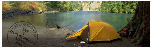
Located near Chester, CA, Lake Almanor offers fishing, boating, water-skiing, swimming, camping and picnicking. Both family and group campgrounds are available. Lake facilities include public boat launch facilities and private marinas.
Unless otherwise indicated, all campsites below are available on first come-first served basis and require a nominal fee of $10 to $18 per night. Most of Lake Almanor area campgrounds are open from May 1 and close November 1. (Please Note: opening and closing dates are dependent upon weather conditions. Also, verify all fee and park information with the Lake Almanor Ranger Station.)
Featured Lake Almanor Resort
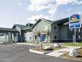 Best Western Rose Quartz Inn ─ Click for reviews and book online
306 Main St., Chester, CA
Nestled among the Sierra Nevada Mountain range in northern California, lies the Best Western Rose Quartz Inn. This Chester hotel is located next to Lake Almanor offering a variety of water activities such as boating, water skiing and fishing.
Lake Almanor Area
Alder Creek Campgrounds -- Tent Camping Only (Elevation 3900') Located on Hwy 32 along Deer Creek, the campground has 6 available campsites. Campground facilities include: restrooms, tables, fire rings, cooking grills, and stream water. Sorry, no piped in drinking water is available.
Almanor Campgrounds -- Tent Camping & RV Parking (Elevation 4550') Located off Highway 89 on the west shore of Lake Almanor, the campground has 103 campsites with available restrooms, tables, fire rings, cooking grills, and drinking water. The campground also has one site and restroom that is handicapped accessible.
Almanor Group Camp can hold up to 100 people. The group site offers restroom facilities, tables, drinking water, fire rings, and cooking grills. Reservations are required and can be made by calling 1-800-280-CAMP. The group campsite costs $100 per night.
Battle Creek Campgrounds -- Tent & Trailer Camping (Elevation 4800') Located on Hwy 36 along Battle Creek, the campground has 50 campsites with available restrooms, tables, fire rings, cooking grills, and drinking water. The campground also has a disabled access campsite with a disabled access restroom.
Benner Creek Campgrounds -- Tent & Small Trailer Camping (Elevation 5562') Accessed via Hwy 36, the campground has 9 campsites located on Juniper Lake Road. The campground facilities include: restrooms, tables, fire rings, and cooking grills. Sorry, only stream water is available--no drinking water.
Black Rock Campgrounds -- Tent Camping Only (Elevation 2100') Accessed via Hwy 36, the campgrounds are located on Ponderosa Way along the banks of Mill Creek. The campground has 6 campsites with restrooms, tables, fire rings, and cooking grills. Sorry, only stream water is available--no drinking water. Weather permitting the campgrounds are open from March 15 to November 15. Be Warned--the unpaved, rough road to the campground is very difficult to navigate and is often impassable after bad weather. 4-wheel drive vehicles are highly recommended.
Butte Meadows Campgrounds -- Tent & Trailer Camping (Elevation 4600') Located off of Hwy 32 on Humbolt Road along Butte Creek, the campground has 13 available campsites. Campground facilities include: restrooms, tables, fire rings, cooking grills, and drinking water.
Cherry Hill Campgrounds -- Tent & Trailer Camping (Elevation 4700') Located off of Hwy 32 on Humbolt Road along Butte Creek, the campground has 25 available campsites (19 sites are suitable for tent & trailer camping; six sites are walk-in only camping). Campground facilities include: restrooms, tables, fire rings, cooking grills, and drinking water.
Domingo Springs Campgrounds -- Tent & Trailer Camping (Elevation 5060') Located off of Hwy 36 on the Wilson Lake/Old Mineral Road, the campground has 18 campsites with available restrooms, tables, fire rings, cooking grills, and drinking water.
Elam Campgrounds -- Tent & Trailer Camping (Elevation 4400') Located on Hwy 32 along Deer Creek, the campground has 15 campsites. Campground facilities include: restrooms, tables, fire rings, cooking grills, and drinking water.
Gurnsey Creek Campgrounds -- Tent & Trailer Camping (Elevation 4700') Located on Highway 36 along Gurnsey Creek, the campground has 31 campsites with available restrooms, drinking water, RV water tank filling hydrant, tables, and fire rings, and cooking grills.
Gurnsey Creek Group Campgrounds Located on Hwy 36, the group camp can accommodate up to 100 people. The group site offers 20 individual campsites, a large group area, restroom facilities, tables, drinking water, fire rings, and cooking grills. Reservation can be made by calling 1-800-280-CAMP.
High Bridge Campgrounds -- Tent and Small Trailer Camping (Elevation 5200') Located off of Hwy 36 on Warner Valley Road, the campground has 12 campsites with available restrooms, tables, drinking water, fire ring, and cooking grills.
Hole-In-The-Ground -- Tent & Small Trailer Camping (Elevation 4300') Located off of Highways 36 & 172 along Mill Creek, the campground has 13 campsites with available restrooms, tables, drinking water, fire rings, and cooking grills. Warning--the campground is not recommended for large trailers because the road to the site is steep, narrow, unpaved, and there is limited turnaround space.
Potato Patch Campgrounds -- Tent & Trailer Camping (Elevation 3400') Located on Hwy 32 along Deer Creek, the campground has 32 campsites. Campground facilities include: restrooms, tables, fire rings, cooking grills, and drinking water.
Rocky Knoll Campgrounds -- Tent & Trailer Camping (Elevation 6000') Accessed via Hwy 36, the campgrounds are located at the junction of Silver Lake Road and Forest Road. The campground has 18 campsites with available restrooms, tables, drinking water, fire rings, and cooking grills.
Silver Bowl Campgrounds -- Tent & Trailer Camping (Elevation 6000') Accessed via Hwy 36, the campgrounds are located off Forest Road 10 on the north shore of Silver Lake. The campground has 18 campsites with available restrooms, tables, drinking water, fire rings, and cooking grills.
Soldier Meadow Campgrounds -- Elevation 4890' (May 1 - November 1) Located off Hwy 89 & County Rd. 308 on Soldier Creek, the campground has 15 campsites with available stream water.
South Antelope Campgrounds -- Elevation 2700' (Open year-round) Located on County Road 202 (off Hwy 36), the park has 4 sites that require no fee. Stream water available.
Warner Creek Campgrounds -- Tent & Trailer Camping (Elevation 5040') Located off of Hwy 36 on Warner Valley Road, the campground has 13 campsites with available restrooms, tables, fire rings, and cooking grills. Sorry, only stream water is available at this location. Drinking water can be obtained at nearby Domingo Springs.
Willow Springs Campgrounds -- Tent & Trailer Camping (Elevation 5100') Located off Highway 36 along Lost Creek, the campground has 14 campsites with available restroom, tables, fire rings, and cooking grills. Sorry, only stream water is available at this location.
Back To Top >>
PG&E Campsites
Rocky Point Campground – Lake Almanor
131 campsites and 2 group campsites (the South Group has 15 to 19 sites available and the North Group has 5 sites available - Call PG&E office @ 916-386-5164 for reservations and fees), fishing, swimming, boat launch nearby, waterskiing, sewage dump station, handicap accessible. Directions: West shore of Lake Almanor. Entrance is on the east side of Hwy. 89 1.5 miles northwest of Lake Almanor Dam. Elevation 4500 ft.
Camp Connery – Lake Almanor
Group campground (fee) up to 50 persons. Call PG&E office at 916-386-5164 for reservations. Entrance on south side of Hwy. 89, 0.1 mile east of Lake Almanor Dam and just west of junction with Hwy. 147. Elevation 4500 ft.
Last Chance Campground – Lake Almanor
12 campsites and 13 group campsites (fee), fishing. Directions: From Chester Fire Station, Take Hwy. 36 east 2.2 miles, turn left and follow left fork 0.1 mile, turn right, go 0.3 mile, turn left, go 0.8 mile and follow left fork 0.9 mile, turn left to Last Chance Creek. Group camp by Reservation Only. Call PG&E Office at 916-386-5164. Elevation 4500 ft.
Ponderosa Campground – Butt Valley Reservoir
63 campsites and overflow camping (fee), fishing, swimming, boat launch nearby, handicap accessible. Directions: North end of Butt Valley Reservoir on east shore. Six miles northwest of Lake Almanor Dam on Hwy. 89, take Butt Valley Road south for 3.2 miles. Elevation 4150 ft.
Cool Springs Campground – Butt Valley Reservoir
25 campsites and 5 walk-in sites (fee), fishing, swimming, boat launch nearby, handicap accessible. Directions: Located 2.5 miles south of Ponderosa Flat Campground on east shore of Butt Valley Reservoir. Elevation 4150 ft.
Yellow Creek Campground – Lake Almanor
11 campsites (fee), fishing. Directions: Southwest of Lake Almanor at southerly end of Humbug Valley. Take Humbug Road off Hwy. 89, 7.5 miles northwest of Lake Almanor Dam, drive 0.6 mile to road intersection. Take road to left (following sign for Humbug Road), go 1.2 miles to fork in road. Take road to right (Following sign for Longville), drive 5.4 miles to Humbug Valley and road intersection. Take road to left, go 0.4 mile to Soda Springs Historic Site. Continue past historical site 0.8 mile to fork in road, take road to right, go 0.3 mile. Elevation 4400 ft.
Back To Top >>