Reno
Reno Area Parks & Open Space
Reno, NV
PARKS & OPEN SPACE

![]()
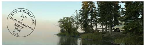
Reno Area Parks & Open Space
Reno/Lake Tahoe has a wide range of diverse ecosystems to explorer – ranging from desert plains to lush forests and crystal clear blue lakes.
For State and Local Parks in and around Reno, Please scroll down the page or click on Reno Area, or Lake Tahoe.
Featured Reno Hotels & Resorts
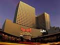 Harrah's Reno Hotel & Casino - Book Online!
219 N. Center, Reno, NV
Harrah's Casino Hotel & Spa is conveniently close to the airport, near Reno City Hall, National Bowling Stadium, and the Pioneer Center for the Performing Arts. Also nearby are the National Automobile Museum and Nevada Museum of Art. The Hotel has a health club, an outdoor pool, and a fitness facility. 24-Hour Room Service Is Available!
Reno Area State Parks,
Beaches and Nature Preserves
1265 Deerlodge Road, Reno, NV (775) 969-3111
The desert wildlife preserve hosts an array of fascinating animals. Open April through October, Thursday through Sunday, 10:00am to 4:30pm. Spring and Fall months, weekends only.
Bureau of Land Management — Carson City
5665 Morgan Mill Rd., Carson City, NV (775) 885-6000
Fort Churchill to Wellington Back Country Byway
A historic town and frontier fort await the visitor along this back country drive. This scenic desert off-road driving tour parallels the Carson River and climbs into the rugged Pine Nut Mountains. Four-wheel drive or high-clearance vehicles are recommended for the climb over the Pine Nut Mountains. Summer and fall are best seasons to travel the byway. It takes roughly four to five hours to drive this byway. More>
Humboldt-Toiyabe National Forest
1200 Franklin Way, Sparks, NV (775) 355-6444.
More than 7,000 acres of public lands for public outdoor recreational use. Paved access is provided by Airport Road, off State Highway 89 midway between Woodfords and Markleeville, California.
P.O. Box 2304, Reno, NV (775) 329-8766
Nevada State Parks Parks
1300 South Curry St., Carson City, NV (775) 687-4384
Historic sites associated with the Pony Express, Transcontinental Telegraph, and Transcontinental Stage are located in the Carson City, Battle Mountain and Ely Districts. There are 30 original stations of which a handful remain standing. Sand Springs and Cold Springs are two of the well preserved stations. Sand Springs Station, adjacent to Sand Mountain Recreation Area has an interpretive trail as well. At Cold Springs Station an interpretive display on the Pony Express Trail is provided adjacent to Highway 50. A two-mile hike at the base of the scenic Desatoya Mountains provides access to the Cold Springs Pony Express Station. More info about the Pony Express >
Approximately 2,450 acres known as PRISON HILL RECREATION AREA has been set aside and dedicated as open space for the Community of Carson City, NV.
Located in the high desert of west central Nevada, 25 miles east of Fallon, the sand dunes of the 4,795 acre recreation area provide challenge and excitement for many types of off-highway vehicle use.
Wellington Backcountry Byway - Fort Churchill
Carson City BLM District Office, 1535 Hot Springs Road, Carson City, NV (702) 885-6000
Walker Lake Recreation Area — BLM
1535 Hot Springs Rd. Carson City, NV (775) 885-6000
One of two large natural lakes in Nevada, Walker Lake provides natural habitat for endangered Lahontan Cutthroat Trout. The 38,000 acre lake has a shoreline which varies from steep and rocky on the west side to fine white beaches on its eastern side. A boat ramp and primitive camping facilities are provided on the western shoreline along U.S. Hwy. 95. More from BLM > More form Public Lands>
Wild Horse and Burro Center at Palomino Valley
P.O. Box 3270 Sparks, NV (775) 475-22220
The center is located on Pyramid Lake Highway about 20 miles north of Reno, NV., and is open Monday through Friday 8:00am to 4:00pm. You can view wild horses and burros by driving the dirt road around the corrals.
Click here for Lake Tahoe Parks and Open Spaces >>
Back To Top >>